
BIM Laser Scanning
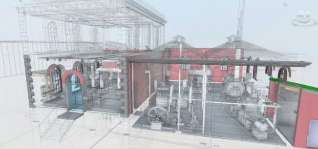
Recon’s BIM laser scanning uses a combination of laser and GPS to produce highly accurate and visually rich models of an existing building. The process is quicker and safer than a manual building survey, and the results are more reliable
LASER SCANNING
Also known as Lidar, laser scanning technology uses a combination of laser beams and a sensor. Laser scanners send out light which reflects off objects and returns to the sensor. The scanner is then able to calculate extremely precise distances based on return times. These distances are recorded as data points. As well as a position, each point is assigned a primary colour value based on the wavelengths of the light returning to the sensor. Because the scanner uses infrared light, it can be placed in a building’s interior to capture spaces even when they are totally unlit. The laser scanner captures everything 360 degrees around it, and a single scan produces millions of data points.
THE 3D POINT CLOUD
Each data point collected by the laser scanner is essentially a 3D coordinate with x, y and z values. In order to accurately survey a building site, these coordinates are mapped against the scanners gps, giving everything its precise location.
The millions of data points form what is called a 3D point cloud - a collection of data that models the shape and colour of the building in minute detail.
THE BENEFITS
Compared to a traditional manual survey of a building, a BIM laser scan is faster and produces a more accurate and data-rich result. It also greatly reduces the risk of human error - in the case of surveys, a single mistake can prove extremely costly for a building project.
Laser scanning can also save money from the outset. It requires less labour and, for some facilities, a manual survey would require a shut-down period. The speed and unobtrusiveness of laser scanning usually means that no shut down is required. For buildings which are dangerous to enter, laser scanning gets the job done safely without putting anyone at risk.
Once a scan is complete and all of the point cloud data has been collected, the results can be easily imported into CAD/GIS software or into our own specialist software, depending on the needs of a project.
Contact us today to find out more about our laser scanning and BIM services.